21/8/53

Old Sukhothai, Sukhothai Map

Old Sukhothai-Sukhothai Map-World Heritage Site-สุโขทัย- ประเทศไทย-thailand

Old Sukhothai-Sukhothai Map-World Heritage Site-สุโขทัย- ประเทศไทย-thailand

Old Sukhothai-Sukhothai Map-World Heritage Site-สุโขทัย- ประเทศไทย-thailand

Old Sukhothai-Sukhothai Map-World Heritage Site-สุโขทัย- ประเทศไทย-thailand

Map Sukhothai Province


Activities of Shukhothai Province

Agrotourism

Cycling Route along the Orchards


Activities of Shukhothai Province-Cycling Route along the Orchards

Some visitors enjoy cycling around the orchards and tasting a variety of fruits like pomelo, santol, sapodilla, coconut, star fruit, various kinds of bananas, as well as the tasty and fleshy plum mango (Bouae Macrophylla) with its chicken-egged size.


Tambon Ban Tuek Community of Amphoe Si Satchanalai. This is a small and peaceful community filled with trees, paddy fields, and scenic mountain ranges, while tourists can enjoy the traditional life of fruit growers. Different types of fruits grown along the hilly terrain include longkong, langsat, mangosteen, durian, banana, pomelo, rambeh, and rambutan.


Eco & Soft Adventure Tourism

Eco-Soft Adventure Tourism-sukhothai

Cycling Route: The Old Town of Sukhothai Trips within the Sukhothai Historical Park are also made by personal or rental bikes.


Spa


Cycling Route-sukhothai-ukhothai Trips-spa

As spa is very famous through out the country, even Sukhothai is not left behind. There is the well-known Ananda Spa at Ananda Museum Gallery Hotel in Sukhothai.


Cycling Route-sukhothai-ukhothai Trips-spa

Sights / Attractions Sukhothai

Sights-Attractions-Sukhothai
Sukhothai Historical Park is located in Tambon Muang Kao, Ampher Muang Sukhothai. It is twelve kilometers away from town. It is opened daily from 8.30 a.m.-4.30 p.m. Ruins of the royal palaces, Buddhist temples, the city gates, walls, moats, dams, ditches, ponds, canals, and the water dyke control system, which were the magical and spiritual centre of the kingdom, are now preserved and have been restored by the Fine Arts Department with the cooperation of UNESCO. It’s not only with a view of fostering Thailand's national identity, but of safeguarding, a fine example of mankind's cultural heritage.

The park covers the ruins of the ancient Sukhothai Kingdom. UNESCO declared it a World Heritage Site in December 1991. During its golden age, Sukhothai was the centre for administration, religion, and economy. The original city was surrounded by walls with 4 city gates. Today the walls house a number of sites worthy of visiting. They include:
The Royal Palace

Wat Mahathat,
The Ramkhamhaeng National Museum
The Ramkhamhaeng Monument
Wat Si Sawai
Wat Traphang Ngoen
Wat Traphang Thong
Wat Chana Songkhram,
Wat Sa Si
Wat Mai
San Ta Pha Daeng (the Deity Shrine)

Tourism Sukhothai

UNESCO World Heritage Site

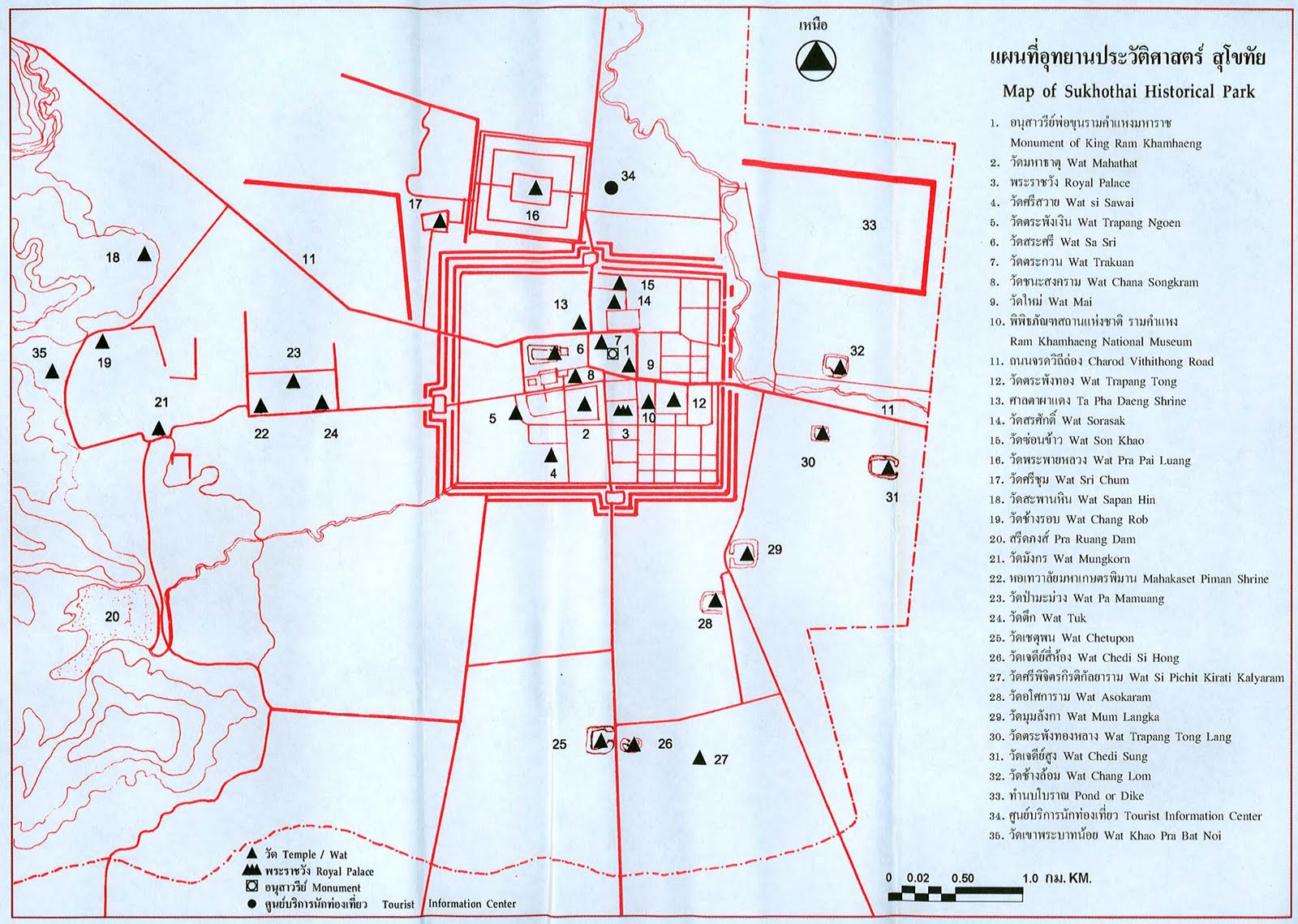
Sukhothai province is most famous for its historical city of Sukhothai, the first capital of Siam, founded by King Ramkhamhaeng. The province’s temples and monuments have been restored well and Sukhothai Historical Park – a place with numerous sites of historical interest – has been made into a UNESCO World Heritage Site. Other interesting places include Ramkhamhaeng National Museum, Ramkhamhaeng National Park, Sri Satchanalai National Park, and The Royal Palace and Wat Mahathat.

Transportation Sukhothai Province

Map-Transportation Sukhothai Province

Roads


There are 5 highways connecting Sukhothai:
Highway 12 connects the eastern districts starting at Ban Dan Lan Hoi and passing Muang and Kong Krailat districts to Phitsanulok province.
Highway 101, starting at Si Satchanalai district, connects the northern districts to the southern districts and passing Sawankhalok, Si Samrong, Muang and Khiri Mat districts to Kamphaeng Phet province.
Highway 102 connects Si Satchanalai district to Uttaradit province.
Highway 1180 connects Sawankhalok district to Si Nakhon district and Uttaradit province.
Highway 1048 connects Sawankhalok district to Thung Saliam district and Lampang province.

Air

The airport is located in Amphur Sawankhalok and is about 30 km away from downtown. Flights operate daily between Sukhothai – Bangkok and Chiang Mai.

Rail

Rail system in Sukhothai is one part of northern route from Bangkok’s Hua Lamphong central station. Sukhothai is located on the main Chiang Mai – Bangkok line.

Songthaew (public passenger pick-up vehicles)

Songthaews are the most popular form of public transport in the new city and the rural areas. Larger sized Songthaews travel to and from the old and new cities.

Bus

Air-conditioned buses run regularly from Sukhothai Bus Terminal to Bangkok and Chiang Mai, stopping off at other major towns on the way. Non air-conditioned buses are for inter-provincial travel to the other districts.

Others

Tuk-tuks and motorbike-taxis are popular for short journeys within the new town.

Symbols of Shukhothai Province

Symbols of Shukhothai Province

The provincial seal shows King Ramkhamhaeng the Great sitting on the Managkhasila Asana throne. Under King Ramkhamhaeng the kingdom of Sukhothai flourished the most.


Provincial tree is Afzelia xylocarpa; provincial flower is the Lotus (Nymphaea lotus).

The provincial slogan is Source of national heritage, the Thai alphabets, the best Loy Krathong celebrations, firm foundation of Buddhism, the fine Teen Jok cloth, ancient chinaware, holy Pho Khun Ramkhamhaeng’s mother, dawn of happiness.


History Sukhothai

History Sukhothai-thailand-สุโขทัย

Sukhothai, meaning the Dawn of Happiness, was a town founded in the 13th century on the fringe of the Khmer empire. The exact year is unknown, but according to the Fine Arts Office it was between 1238 and 1257. Founded by Phokhun Si Intharathit, it was the first truly independent Thai (Siamese) Kingdom after defeating the Khmers. Sukhothai enjoyed a golden age under their third king, King Ramkhamhaeng, who was credited with creating the Khmer-derived Thai alphabet which is essentially the same as that in use today.[2] He also laid the foundation for politics, the monarchy and religion, as well as expanding its boundary of influence. Sukhothai was later ruled by many kings. The province is most famous for the historic city of Sukhothai, the capital of the Sukhothai kingdom. It is located about 12 km from the modern New Sukhothai city. Not far from Sukhothai are the Si Satchanalai historical park and the Kamphaeng Phet Historical Park. Both were cities within the former Sukhothai kingdom and of the same time period.

The province was at first known as Sawankhalok; it was renamed to Sukhothai in 1939.

Geography of Sukhothai

Geography of Sukhothai

Sukhothai is located in the valley of the Yom River on the lower edge of the northern region, 427 kilometres north of Bangkok, and covers some 6,596 square kilometres.


The Khao Luang Mountain Range, with its four main peaks: Khao Phu Kha, Khao Phra Mae Ya, Khao Chedi, and Pha Narai, lies within the Ramkhamhaeng National Park in the south of the province.[1] The Si Satchanalai National Park is located in the north-west, protecting the mountainous forest areas of the province.

Sukhothai Province

Sukhothai Province

Sukhothai (Thai: สุโขทัย) is one of the northern provinces (changwat) of Thailand. Neighboring provinces are Phrae, Uttaradit, Phitsanulok, Kamphaeng Phet, Tak, and Lampang. Sukhothai can be translated as Dawn of Happiness.

On Sukhothai

Sukhothai
กำเนิดอักษรไทย งานใหญ่ลอยกระทง มั่นคงพุทธศาสนา พระแม่ย่ามิ่งเมือง อดีตรุ่งเรือง คือเมือง สุโขทัย

ยินดีต้อนรับสู่ สุโขทัย108 เว็บไซต์สำหรับคนสุโขทัย

อุทยานประวัติศาสตร์เมืองเก่า มรดกโลก

Shout Box


ShoutMix chat widget